WMEX Boston
Listeners:
Top listeners:
-
 play_arrow
WMEX WMEX Boston
-
 play_arrow
Courage To Hope-Episode 82-Michael Courage To Hope-Episode 82-Michael
Ancient lake that reemerged at Death Valley National Park is here to stay — for now, rangers say
todayFebruary 19, 2024

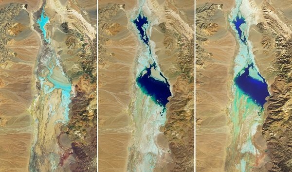
This series of images compares the desert basin before flooding (left) with its more-waterlogged state following each major storm. In both August 2023 (middle) and February 2024 (right), a shallow lake several kilometers across fills in the low-lying salt flat. CREDIT: NASA Earth Observatory
(NEW YORK) — An ancient lake that reemerged at Death Valley National Park last year will stick around for longer than initially expected now that several rounds of extreme rain have poured through Southern California, according to officials.
Death Valley’s famed Badwater Basin began filling up with water in August due to heavy precipitation from Hurricane Hilary, which prompted the first tropical storm watch in California state history, Abby Wines, park ranger at Death Valley National Park, told ABC News last month. During that event, more than 2 inches of water fell on Aug. 20 — the amount the region typically sees in a year.
Park rangers initially estimated that the water filling up several inches in the basin where the Ice Age-era Lake Manly once stood would only last until February. But storm systems fueled with potent atmospheric rivers in recent weeks has expanded the lake once again, satellite images released by NASA show.
Much of the precipitation occurred between Feb. 4 and Feb. 7, when 1.5 inches of water fell in the park, according to a statement released by the National Park Service on Friday. The series of satellite images shows how the lake expanded from virtually no water on July 5 to being filled with water from August through February.
Death Valley is the driest place in North America, with a typical rainfall total of about 2 inches per year, according to NASA. In the past six months, the region has received nearly 5 inches of rain, records show.
At this point, park rangers are uncertain how long the lake will last.
Another round of atmospheric rivers are forecast for the region on Monday through Wednesday.
At its peak, Lake Manly once held up to 700 feet of water. Currently, at about 6 miles long, 3 miles wide and 1 foot deep, the temporary lake in Badwater Basin is deep enough to kayak in, a “rare opportunity,” Wines said in a statement on Friday.
It was deep enough to kayak in August as well, but visitors were not able to partake because the park remained closed until October, in which the temporary lake had already reduced by several inches, according to the NPS.
“Now most of the main roads are open, so it’s a great time to come visit!” Wines said.
Badwater Basin is known for its place at the lowest elevation in North America, at 282 below sea level. The basin, normally a saltwater flat, is endorheic, meaning that water flows into but not out of it.
The evaporation rate in the desert, combined normally low amounts of precipitation, typically do not allow water to collect in the basin for long.
“You might think with no drain to the sea, that Death Valley would always have a lake,” Wines said on Friday. “But this is an extremely rare event. Normally the amount of water flowing in is much less than the evaporation rate.”
Visitors have enjoyed witnessing stunning reflections of the surrounding mountain peaks in the calm waters resting in the basin, Wines said.
Tiffany Lin, a travel and hiking blogger in her mid-30s, described the water to ABC News last month as having a “vibrant reflection” to it.
“It was perfectly clear,” said Lin, who drove from her home in Orange County, California, over Thanksgiving weekend to see the lake.
ABC News’ Dan Manzo contributed to this report.
Copyright © 2024, ABC Audio. All rights reserved.
Similar posts
CONTACTS
- https://wmexboston.com
- 781-834-WMEX(9639)
- studio@wmexboston.com
- 130 Enterprise Dr, Marshfield, MA 02171
ABOUT
WMEX Boston can be heard at 1510 AM, and 101.1 FM. Playing the greatest hits from 50s, 60s, 70s, 80s, and more!
MENU
SPONSORS
Copyright 2024 WMEX Boston - Design by Pro Radio Solutions


